The City of Humboldt is centrally located in the province of Saskatchewan. Humboldt can be accessed by provincial Highways 5 and 20. Highway 5 runs east and west and Highway 20 runs north and south. Humboldt is 113 kilometers east of Saskatoon along Highway 5. Humboldt is 39 kilometers north on Highway 20 from the Highway 16 and Highway 20 junction. Highway 16 is also known as the Yellowhead highway. Humboldt is 42 kilometers east of Highway 6.
Humboldt is: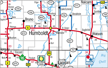 -
150 miles/219 km north of Regina, SK -
70 miles/113 km east of Saskatoon, SK -
420 miles/672 km east of Edmonton, AB -
454 miles /731 km east of Calgary, AB -
425 miles/680 km west of Winnipeg, MB -
250 miles/400 km north of the U.S. border The City of Humboldt map has a comprehensive street index, points of interests and parks listing- click to view or download the City of Humboldt Map
View the City of Humboldt Zoning Map
View the Humboldt Trading Area map
View the Central Saskatchewan highway map
|