|
Geographical Data
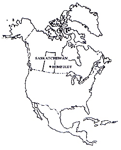 Location:
The City of Humboldt is strategically located in central Saskatchewan. Located on Highway #5 and Highway #20, Humboldt is 655 kilometres (390 miles) west of Winnipeg, about the same distance east of Edmonton and 728 kilometres (432 miles) east of Calgary. Regina lies almost directly to the South, located 231 kilometres (138 miles), Saskatoon is about 113 kilometres (66 miles) to the west, and from Humboldt to the U.S.A. border is 350 km (210 miles). Humboldt lies in what is known as the Park Country, as distinguished from the open prairie.
Climate:
Climate Characteristics
On average, the month of July is the warmest month in Humboldt averaging 17.7 degrees Celsius. The coldest month during the winter season is, on average, in January.
Based on the latest statistics from Environment Canada, the average temperatures are shown in the table below:
Average Temperatures (Degrees Celsius)
|
| January |
-19.8 |
July |
17.7 |
| February |
-16.1 |
August |
16.9 |
| March |
-9.6 |
September |
10.4 |
| April |
1.9 |
October |
3.0 |
| May |
10.3 |
November |
-6.9 |
| June |
15.1 |
December |
-15.0 |
Source: Climate Research Atmosphere Service,
Environment Canada, Regina. |
|